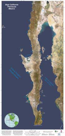
This poster shows the peninsula, gulf and mainland Mexico in their "true" colors (as you would see them from an airplane). It includes annotation of the main cities, paved roads, and many bays and islands. It also includes state and international borders, scale bars to measure distance, north arrow, legends, and Latitude Longitude grid lines at 2-degree spacing. Most text is printed in both English and Spanish.
The poster measures 23.5 inches wide by 49.5 inches tall with UV coating to resist fading. Order the standard version for indoor use or framing, or the laminated (plastic coated) version for extra durability and weather resistance. Prices includes all taxes and shipping to anywhere in the United States.
The poster was produced by Earthstar Geographics LLC in conjunction with our Mexican partners Baja Image Makers and CICESE.